
Colorado Statewide Post-Wildfire Susceptibility Analysis
Statewide Study Mission
Determine the susceptibility of Colorado’s water resources, communities, and critical infrastructure to post-wildfire impacts.
This effort relied on existing statewide datasets for project wildfire burn severity, critical water supplies, populations at risk, and infrastructure. The identification of post-fire hazards used a combination of existing hazard mapping, geologic and topographic data, and other related information to determine potential impacts on values at risk.
Collaboration with basin roundtables, state and federal agencies, universities, and other community partners was critical in determining the best, most applicable data and data analysis methods.

Statewide Study Goals
Define
Define and identify post-wildfire hazards that threaten life safety, property, infrastructure, and water supplies.
Identify
Identify the elements of an effective education and communication program that relays the findings, action items, and tools of the assessment.
Encourage
Encourage the use of planning and land management actions to protect the health and resilience of watersheds, wetlands, and stream corridors as a strategy to reduce susceptibility to hazards following wildfires.
Advance
Advance a watershed and landscape scale approach to wildfire planning and recovery.
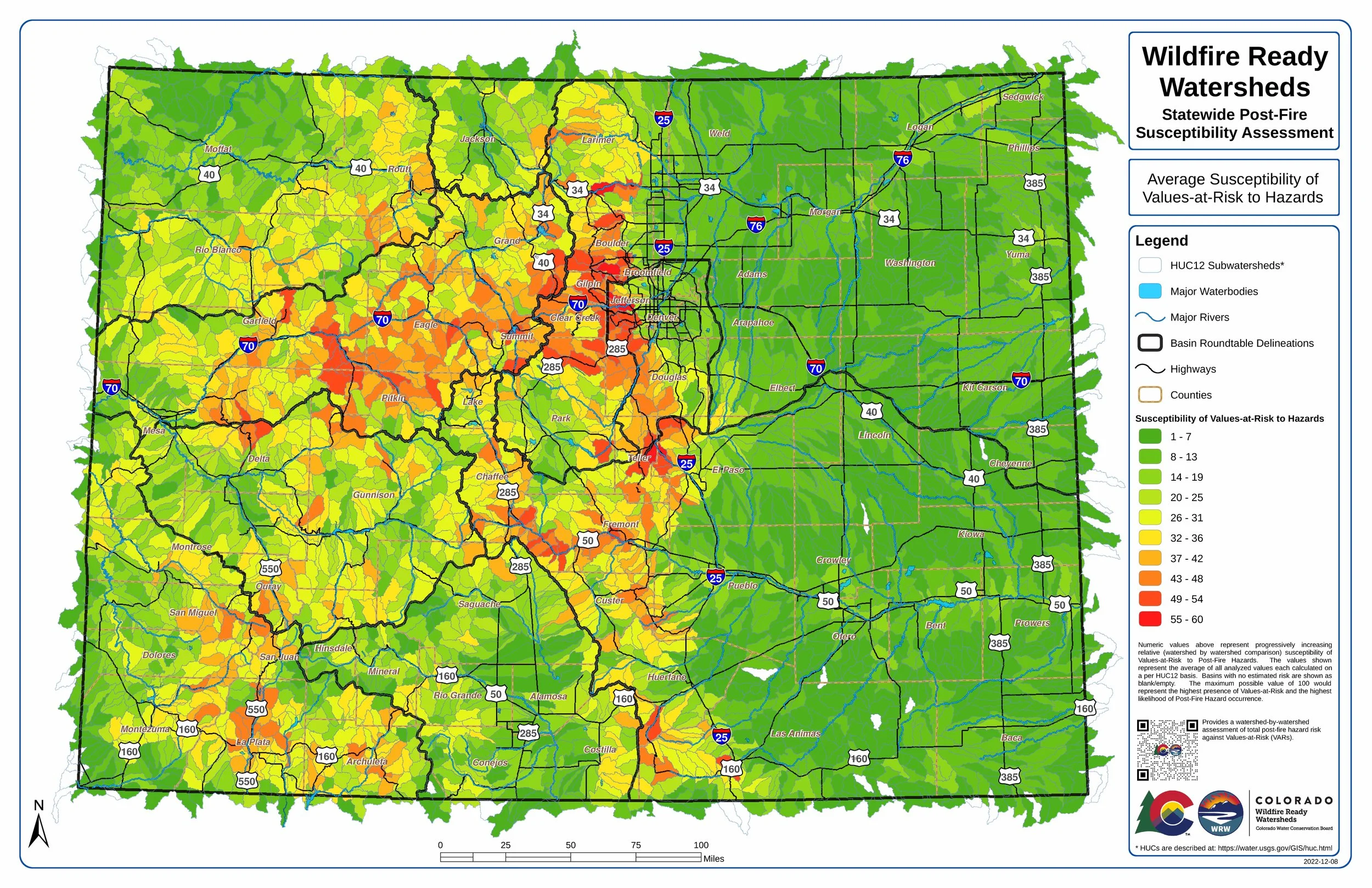
Colorado Post-Fire Susceptibility
-
![]()
life and property Susceptibility
Provides a watershed-by-watershed assessment of total post-fire risk against Life and Property Values-at-Risk (VARs). Life and Property includes buildings and transportation infrastructure.
-
![]()
Overall Susceptibility in Colorado
Provides a watershed-by-watershed assessment of all post-fire hazards and all Values-at-Risk (VARs).
-
![]()
Water Infrastructure Susceptibility
Provides a watershed-by-watershed assessment of total post-fire risk against Water Infrastructure Values-at-Risk (VARs).


Want to know more about where post-fire hazards impact assets in Colorado?
Explore Colorado’s susceptibility with an interactive map viewer.

HOW THESE MAPS WERE CREATED
It’s important to understand how the data behind these maps were compiled, how it was modified or created, and the intended uses and limitations of these watershed-scale maps. Detailed descriptions of the mapping process are provided at the link below.
These maps reflect risk which is a combination of a community’s values or assets and the presence of post-fire hazards.
The values and assets were identified using existing state-wide datasets from various agencies and organizations including CWCB, DNR, CPW, and CDOT. Assets were inventoried in each HUC-12 watershed and the watersheds were then ranked relative to one another based on the number and importance of assets in each one.
With the exception of flooding where an existing data set was used, all other post-fire hazard analysis was performed as a part of this study. Each HUC-12 watershed in the State of Colorado was evaluated for the presence and degree of each hazard and then was ranked relative to the other watersheds in the state.
After cross-referencing the assets with the hazards that can impact them, maps were created that show the risk or susceptibility of each asset to each hazard (for example, which watersheds have reservoirs that may be impacted by debris flows). By combining these individual asset and hazard maps, the comprehensive susceptibility map was created showing the overall susceptibility of the State of Colorado to Post-Fire hazards.
Explore the Values at Risk


Reservoirs + Dams

Transportation Network
Municipal Water
Life + Property
Aquatic Ecosystems
Ag Water
Explore the POst-Fire Hazards


Flooding
Debris + Mud Flows


Hillslope Erosion
Riverine Erosion + Sedimentation
